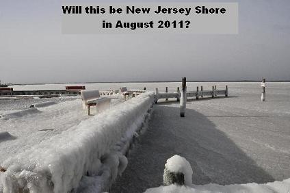
 Never mind what the Farmer’s Almanac says, and forget about the global warming nuts, because the Summer of 2011 is predicted by experts to be the coldest summer in recorded history of the Northeast of the USA. The weather disaters we are seeing now in the southern states is the evidence that something happening thousands miles away quite possibly, according to one expert, could give the Eastern USA a year with no Summer.
“There is a very active La Nina in the Pacific and this is what is spawning the tornadoes in the southwest,” said weather analyst Foddy Ga-Thode, who is already seeing his prediction come true with May 2011 being the coldest May since 1959.
“I am forecasting a June and July average high of 78 with evening lows in the upper 50s. I also foresee very low temperatures along the coastline from Maine to North Carolina with the shore areas of New Jersey and Delaware seeing the most marked decline. It’s not out of the question that warm air currents swirling around the south central USA could aggressively pull down very cool air from Northern Canada. Oddly enough the cold air will pass high over the surface in Canada and the Dakotas leaving them with normal summer temperatures, but then that air will descend and get pushed to the eastern shore where it will hang around for most of the summer. Temperatures could drop as low as near freezing in the August evenings.”
Foddy Ga-Thode is basing his model on a French weather disturbance that happened in France in 2007 where they had “the year without a summer.” That year, northern France was cold and rainy throughout the whole summer and the population fled to the south of France where the temperatures were relatively normal. This came after the summer if 2003 where the temperatures in France stayed over 100 degrees for weeks on end and many elderly French people simply died in their apartments. This set up a sequence of event in the North Atlantic that cycled into a 4-year severe downdrop in the incoming jet stream from the Arctic.
“I see a similar pattern developing now in the Eastern USA, and while this cool air will be great for campers and hikers, it will destroy the summer economies of many beach resort cities and states who rely on that summer fun dollar, ” continue Ga-Thode.
“The easy way to think of it is when you think about the temperature outside of a high flying aircraft. You may be flying over a tropical jungle but at an altitude of 35,000 feet the air outside your cozy cabin is about -20 degrees F. Think about what would happen if 40% of that air were to drop down and hug the eastern coastline of the USA. The sun will be able to heat it to the upper 70s on a cloudless day, but in the early morning hours and on sunless days, you will have very cold air mixing with warm air. You will not only get cold nights, you will have days of extreme changes in barometric pressure where thunder and hail storms could be extremely beyond the intensity of any we have ever seen.
“The other possibility is that this cold will lift as the jet stream changes it’s serpentine movement and sets up for a blistering hot autumn and at least 1 month of winter where the temperature never drops below 80 degrees, It could be a very crazy year.”


